Starting today, two waves of cold air will affect our country one after another. Most areas will cool down by 6 to 10 degrees Celsius, and the temperature will hit a new low next week. Affected by the intersection of cold and warm air, a new round of large-scale rain and snow will also hit the central and eastern regions. Snowfall will hit the line in Gansu, Shaanxi, and Shanxi. There may be heavy snowstorms in some parts of the northeast, and moderate to heavy rains in many places in the south.
Two waves of cold air from the east and west are coming, and the temperature will hit a new low
From today to the 18th, two waves of cold air from the east and west will move southward and affect our country. Although the strength of the cold air is average, because most areas are currently warmer, it will cause a larger cooling rate. Most areas will cool down by 6 to 10°C, and the local drop in eastern Inner Mongolia and eastern Northeast China will exceed 12°C.
Before the cold air arrives, today and tomorrow, the highest temperatures in the eastern part of Northwest China, central and southern North China, southern Northeast China, and Huanghuai will be around 15°C. From the 16th to the 17th, the temperature dropped in many places. Among the big cities, Xining will drop from nearly 15℃ yesterday to 4℃ on the 16th; the highest temperature in Jinan today will be 18℃, and it will drop to 9℃ on the 17th, with a clear change between cold and warm.
The temperature in the south will cool down slightly later than in the north. Around the 18th, temperatures will hit record lows in the second half of this year. The highest temperature in the middle and lower reaches of the Yangtze River is only about 10°C. The public needs to adjust their clothing in time according to temperature changes to avoid catching colds.
A new round of precipitation is coming, with heavy snowfall in some parts of Northeast China
Affected by the South Branch Trough, rainfall continued across a large area in the south yesterday. Heavy to heavy rains occurred in southern Zhejiang, eastern Hubei, southern Jiangxi, southern Hunan, Guangdong, Guangxi, Hainan Island and other places. The coastal areas of Guangdong and southern Hainan Island experienced heavy rains.
As a new wave of cold air moves south, the warm and humid air flow gradually strengthens, and a new round of large-scale precipitation hits the central and eastern areas. It is expected that in the three days from today, there will be moderate to heavy snow or sleet and localized blizzards in parts of the eastern part of northwest China, south-central Inner Mongolia, western and northern parts of North China. From the 17th to the 18th, there will be heavy to heavy snowfalls, localized heavy snowstorms or extremely heavy snowstorms in parts of eastern Jilin, eastern Heilongjiang and other places. In addition, from the 15th to the 17th, there were light to moderate rains in the Huanghuai and south areas, and heavy rains in some areas in Jiangnan, South China and other places.
Specifically, today, there will be moderate to heavy snow or sleet in parts of northern and eastern Xinjiang, eastern Qinghai, central and southern Gansu, northern and southern Ningxia, western and northeastern Inner Mongolia, and there will be heavy snowfall in Xinjiang along the Tianshan Mountains. There were moderate to heavy rains in parts of eastern Guangdong, Fujian, southeastern Jiangxi, northern Zhejiang, and Taiwan Island. Among them, there were local heavy rains in eastern Guangdong and southeastern Fujian.
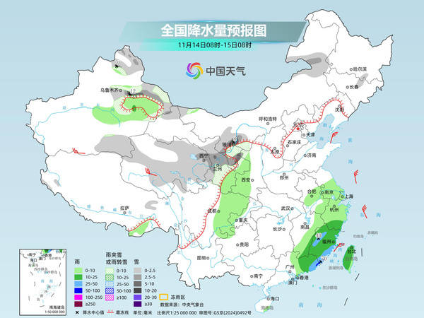
Tomorrow, there will be moderate to heavy snow or sleet in parts of the Ili River Valley in Xinjiang, central and southern Inner Mongolia, northeastern Ningxia, northern Shaanxi, and the Qinling Mountains, central and northern Shanxi, northwest Hebei, and northwest Beijing. Among them, there will be heavy snowfall in northern Shaanxi, northern Shanxi, and central and southern Inner Mongolia. There are light rains in parts of eastern Xinjiang, eastern Gansu, Shaanxi, western Henan, southern Shanxi, southern Hebei, Beijing, eastern Sichuan, northeastern Yunnan, Chongqing, Guizhou, western Hubei, western Hunan, most of Guangxi, southwestern and eastern Guangxi, Fujian, southern Zhejiang, Hainan Island, Taiwan Island and other places. Among them, there are moderate rains in parts of northeastern Sichuan, northeastern and southern Shaanxi, and central and western Shanxi.
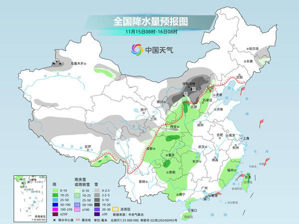
The day after tomorrow, there will be moderate to heavy snow or sleet in parts of southeastern Tibet, the northern part of the Western Sichuan Plateau, and the Qinling Mountains of Shaanxi. Among them, there will be local heavy snowfall in the Qinling Mountains of Shaanxi. There are light to moderate rains in parts of southeastern Northwest China, southern North China, western Jianghuai, western Huanghuai, Jianghan, Jiangnan, eastern Southwest China, and western South China. Among them, there are heavy rains in parts of southeastern Chongqing, southern Hubei, and northwestern Hunan.
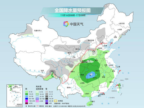
Many parts of the north will experience significant rain and snow, and the Northeast may encounter heavy snowstorms. People need to be alert to the adverse effects of icy roads and snow on traffic. Since the forecast timeliness is far away, the public needs to pay attention to the latest forecast and warning information.
Related Reading
- SpaceX Starship succeeds in first orbital recovery of spacecraft2026-11-15
- Some electric bicycles are stuck in 3C certification, and consumers face obstacles in getting licenses.2026-11-15
- Nowadays, variety shows are full of NPD mothers. What is NPD?2026-11-15
- Remember to put on some clothes when you go out! Two waves of cold air hit one after another, with the local drop exceeding 12℃2026-11-15
- U.S. shipping will return to normal on the evening of the 15th, and the nationwide suspension will last for 5 hours.2026-11-15