This article is reproduced from [CCTV News Client];
From today (November 15th) to the 18th, two waves of cold air have successively affected my country. The temperature in most areas of the central and eastern regions has dropped by 6 to 10℃, and the local drop will exceed 12℃. After the cooling, the temperature will hit a new low in the second half of this year in a large area. The lowest temperature will be around the 17th in the north and around the 18th in the south. In addition to cooling, large-scale rain and snow are also coming, with localized blizzards in the north and mainly rainfall in the south.
Two waves of cold air are coming, the chill in the north is getting worse and the autumn in the south is deepening
Starting yesterday, the cold air became active, and two rounds of cold air will affect our country today and tomorrow and from the 17th to the 18th. This cold air will mainly affect the area north of the Yangtze River today and tomorrow. The cold air will be strong from the 17th to the 18th and will affect most of the central and eastern regions.
The cumulative cooling brought by the two rounds of cold air is outstanding. The temperature in most areas of the central and eastern regions has dropped by 6 to 10°C. The local temperature in western and northern North China, the south-central region of Inner Mongolia, the eastern part of Northeast China, and the northeastern part of Jiangnan will drop by more than 12°C.
After the temperature drops, the cold will intensify in the north and the autumn will deepen in the south. The temperature will reach a new low in the second half of this year in a large area. The temperature lows in the north are mainly concentrated around the 17th, and the lows in the south are mostly around the 18th. The 0℃ maximum temperature line will press southward to northern North China, and the 10℃ line will reach the central Huanghuai River.
Among large cities, the highest temperature in Hohhot will drop to 0℃ for the first time in the second half of this year on the 17th, while Nanjing and Shanghai will drop to 10℃ or below on the 17th.
While the temperature is cooling, most areas in the central and eastern regions have winds of magnitude 4 to 6 and gusts of magnitude 7 to 8, and atmospheric diffusion conditions will improve. The public needs to pay attention to temperature changes and add clothing in time to avoid catching colds.
A new round of precipitation is coming, with snow falling in many places in the north and widespread rainfall in the south
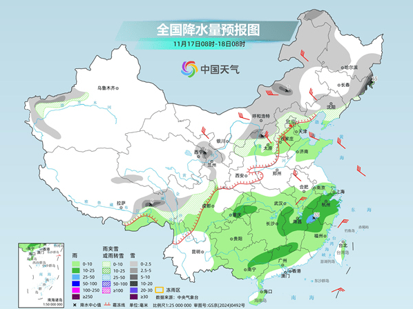
The intersection of cold and warm air has also brought widespread rain and snow to the central and eastern regions. In the next three days, there will be moderate to heavy snow or sleet and local heavy snow in parts of the eastern northwest, central Inner Mongolia, western and northern parts of North China, and localized heavy snow; there will be light to moderate rain in the Huanghuai and south areas, and heavy rain in parts of Jiangnan and South China. From the 17th to the 18th, there were severe to heavy snowfalls in some areas of eastern Jilin, eastern Heilongjiang and other places, and heavy snowstorms occurred locally.
Specifically, today, there will be light to moderate snow or sleet in parts of northern Xinjiang, northern and eastern Tibet, central and southern Qinghai, central and western Inner Mongolia, central and northern Shanxi, northern Hebei, western and northern Beijing, northeastern Jilin, and southeastern Heilongjiang. Among them, there will be heavy snow in some areas of central and western Inner Mongolia, northwest Hebei, and local heavy snowfall. There will be light to moderate rain in parts of the eastern part of Northwest China, central and western North China, western Huanghuai, eastern Southwest China, Jianghan, Jiangnan, and western South China.
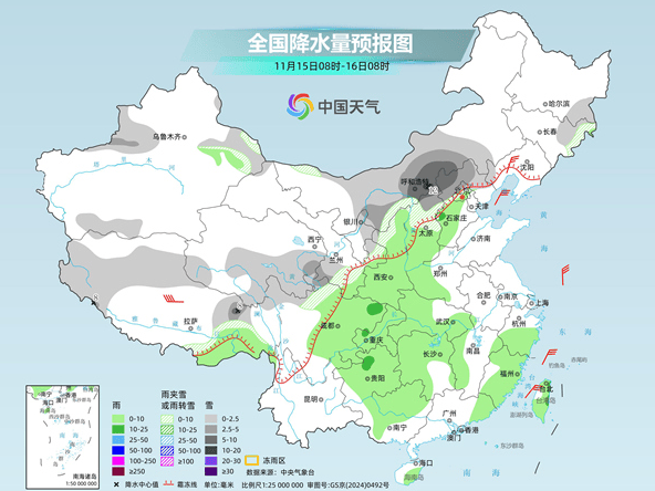
Tomorrow, there will be light to moderate snow or sleet in parts of Xinjiang’s Ili Valley, eastern Tibet, eastern and northern Qinghai, central and western Gansu, central and western Inner Mongolia, northern Shaanxi, and the Qinling Mountains, central Shanxi, northern Hebei, and eastern Jilin. Among them, there will be heavy snow or blizzard in parts of the Xinjiang Ili Valley, northeastern Tibet, Gansu Hexi, Shaanxi Qinling Mountains, and eastern Jilin. There are light to moderate rains in parts of southeastern Northwest China, southern North China, central and western Huanghuai, Jianghan, central and western Jianghuai, eastern Southwest China, Jiangnan, and western South China. Among them, there are heavy rains in parts of northern Hunan, southeastern Chongqing, and northeastern Guizhou.
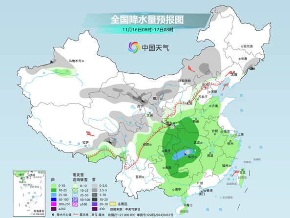
The day after tomorrow, there will be light to moderate snow or sleet in parts of the western mountainous areas of southern Xinjiang, eastern Tibet, central and eastern Inner Mongolia, northeastern Northwest China, central and northern North China, eastern and northwest Northeastern regions. Among them, there will be heavy snow locally in northeastern Jilin, southeastern Heilongjiang, central Inner Mongolia, northeastern Qinghai, Gansu Hexi, northwest Shanxi, and eastern Tibet, and there will be heavy snowfall locally in northeastern Jilin. There are light to moderate rains in parts of central and southern North China, northeastern Huanghuai, Jianghan, southern Jianghuai, eastern Southwest, Jiangnan, and South China. Among them, heavy rain occurs in parts of northeastern Jiangxi, southwestern Zhejiang, and northwest Fujian.
Related Reading
- SpaceX Starship succeeds in first orbital recovery of spacecraft2026-11-15
- Some electric bicycles are stuck in 3C certification, and consumers face obstacles in getting licenses.2026-11-15
- Nowadays, variety shows are full of NPD mothers. What is NPD?2026-11-15
- U.S. shipping will return to normal on the evening of the 15th, and the nationwide suspension will last for 5 hours.2026-11-15
- The snow holiday is coming, and many places have officially announced it!2026-11-14